
The island of Cyprus was already divided in to two, far before 1974.
The physical division of Nicosia took place in 1956 when the isl-and was under British colonial rule. Colonial Government erected a barbed wire division between the Greek and Turkish community in the city of Nicosia, known as the “Mason-Dixon Line” after the first inte-rethnic clashes.
This was the maiden division of the city and plantation of the partition seeds in the island.
Later, in 1958, renewed and more protracted interethnic violence flared up and led once more to a division of the capital and the island. From that time onwards, both communities established separate municipal councils and the issue of whether the municipalities were to be separate or not was left open in the 1960 Cyprus Constitution.
In 1958, following the eruption of interethnic clashes and the proposal of a partitionist plan by the British Government, the Greek community, led by Archbishop Makarios, accepted a solution of limited independence whose basic premises had been elaborated in Zurich by the Governments of Greece and Turkey.
The constitution in particular, categorized citizens as Greeks or Turks. Elected positions were filled by separate elections. Separate municipalities were established in each town and separate elections were to be held for all elected public posts.
The posts filled by appointment and promotion, such as the civil service and police, were to be shared between Greeks and Turks at a ratio of 7:3. In the army this ratio rose to 60 to 40. The President was designated Greek and the Vice President Turkish, each elected by their respective community. In the House of Representatives fiscal, municipal and electoral legislation required separate majorities.
Since then the life styles of both communities in the island of Cyprus were already separated.
In 1963, after the Turkish members of the House of Representa-tives had rejected the one sided budget, aiming investments only to Greek sectors of the island, President Makarios decided to convert the bicommunal Cyprus Government into Unitary Greek Majority Govern-ment by violent force. In December 1963, as per the AKRITAS plan, which was designed by P. Yorgadgis, and T. Papadopulos on 1961, interethnic tensions rose artificially by the provocations of the Greek police and militia, and armed clashes broke out. Turkish civil servants were kicked out from their posts and Parliamentarians from House of Representatives.
The Cyprus Government of the Greek majority encouraged armed Greek civilians to take part in the clashes and in a very short period 103 Turkish villages were grounded and their inhabitants, who ma-naged to save their lives, fled to Turkish enclaves.
The Turkish enclaves, which formed the roots of the division on the island, were only 3% of the total area of the island and was like an open prison. A Turkish Cypriot genocide was put in effect and freedom of movement, property ownership and employment was restricted to Turkish Cypriots from 1963 to 1974.
There are two communities on the island since than and they speak of themselves as Turkish Cypriots and Greek Cypriots. Greek Cypriots belong to the Greek Orthodox Church, speak Greek and share the culture of their motherland Greece, whereas Turkish Cypriots are Moslems, speak Turkish and assume their motherland Turkey’s values. The two communities do not have the feeling of belonging to a Cypriot nation and they have been completely separated.
The island was divided by the Greeks on 1963 and not by the Turks on 1974, as most of the people thinks so.
This horse is not as mythological as you might think at first glance. The beast we are thinking of is a political “Trojan horse” and the heads are on both ends. It can trot in both directions, forward and backwards, simultaneously.
This 21st Century two-headed-beast was established recently by China and Greek Cyprus. The President of Greek Cyprus, Mr. Thassos Papadopulos, paid a visit to China at the invitation of President Hu Jintao on the occasion of the 35th anniversary of the establishment of diplomatic relations between the Republic of Cyprus and the People’s Republic of China.
Though their relative size is noteworthy, China having a popula-tion of 1.3 billion, and Greek Cyprus a mere 750 thousand, they de-clared their mutual gratitude to each other last night and wished for a lasting solidarity.
The vice-chairwoman of the National People’s Congress of China Wu Yun Qi Mu Ge, deeply thanked Cyprus for its support to China within the EU and noted that China has a good friend and partner within the European Union.
With his reply, President of Greek Cyprus Mr. Papadopulos ex-pressed Cyprus’ gratitude for China’s support to the efforts for a just and viable solution of the Cyprus question on the basis of the United Nations Security Council Resolutions, European principles and inter-national law.
Their political solidarity, on top of economic and cultural ties, calls to mind the ‘special relationship’ between the USA and the UK, and the “Trojan horse” role the UK plays within the EU.
While the arms embargo imposed on China after the Tianenmen square crackdown on democratic protestors is still firmly standing, and while China is experiencing obstacles with her textile and shoe exports to the EU, they are willing to ease and smoothen relations with the Union more than ever before.
Under these circumstances, any country in EU which gives sup-port to Chinese matters is invaluable, relying on the fact that each EU member has equal voting weight in the European parliament, irrespec-tive of the size of their population.
As a good example is the proposal of Greek Cyprus in the discus-sion of Customs Tax to be imposed on Chinese textile and shoes, the proposed 5 years were dropped to 2 years.
While Greek Cyprus undertakes such actions for China in the EU, Cyprus equally pushes China for a similar “Trojan Horse” role in the UN Security Council for matters related to Cyprus, especially relating to her problems concerning the Northern territories of the island, namely the Turkish Republic of Northern Cyprus, the KKTC.
China’s concern with Cyprus is due not only to EU relations, but also due the resemblance of the case of Cyprus to China’s headache with Taiwan.
One of the solutions proposed for the settlement of Cyprus issue is the Taiwanese type recreation of TRNC. While China is after annexation of Taiwan, Greek Cyprus is after annexation of TRNC. And both are determined not to give any compromises.
Taiwan overcame political isolation by her strong industry and economical relations with the rest of the world. If the Western world supports the application of the Taiwanese model to TRNC for the solu-tion of Cyprus problem, this would weaken the foreign policy of China regarding Taiwan. She would never accept such a solution and vote against it in UN Security Council and stand firmly by the Greek Cyprus Government.
Exchanging similar roles in the parties where they have a seat, each will serve as the other’s “Trojan horse” for their final mutual ben-efit and solidarity
You’ll be reading my maiden article in “my column” on Jan 21st, 2007, right after the first couple of issues of Today’s ZAMAN.
Most probably you’ll be wondering “who’s this guy” and what would be the contents of his column.
Actually I am a Turkish Cypriot and an academician with a very interesting background.
Well educated in US universities and elected as a Member of Par-liament, representing the constituency of Famagusta in the National Assembly at the age of 26.
Of course, after entering the politics at so young age, I couldn’t escape from it, nor the politics could wiped me out.
Political experience as a parliamentarian, turned out to be a fur-ther postgraduate study for me, later in my life.
In depth history knowledge on top of my engineering education, backed by the thirty years of political experience, opened further doors like head of Cyprus Turkish delegation during UN’s Annan Plan nego-tiations in Cyprus, advisor to deputy Prime Minister and the member-ship to the Board of the International Scientific Academy.
Have been writing political articles and commentaries in various local newspapers since 2003 and now they are above 1000 in number.
You’ll be hearing non aligned, non committed, non attached crys-tal clear facts about Cyprus, political history of Cyprus, Cyprus issue, EU-Turkey membership negotiations and realities behind the curtains of Cyprus, Brussels and Ankara triangle.
1) Abstract :
The names and identities of the Antique Monuments, with in the oldtown of Famagusta, Cyprus are determined according to the historical documents or to the historical records in hand or in the national archives. Most of the times, due lack of the true records or original documents or real details, wrong information or wrong names are in daily use.
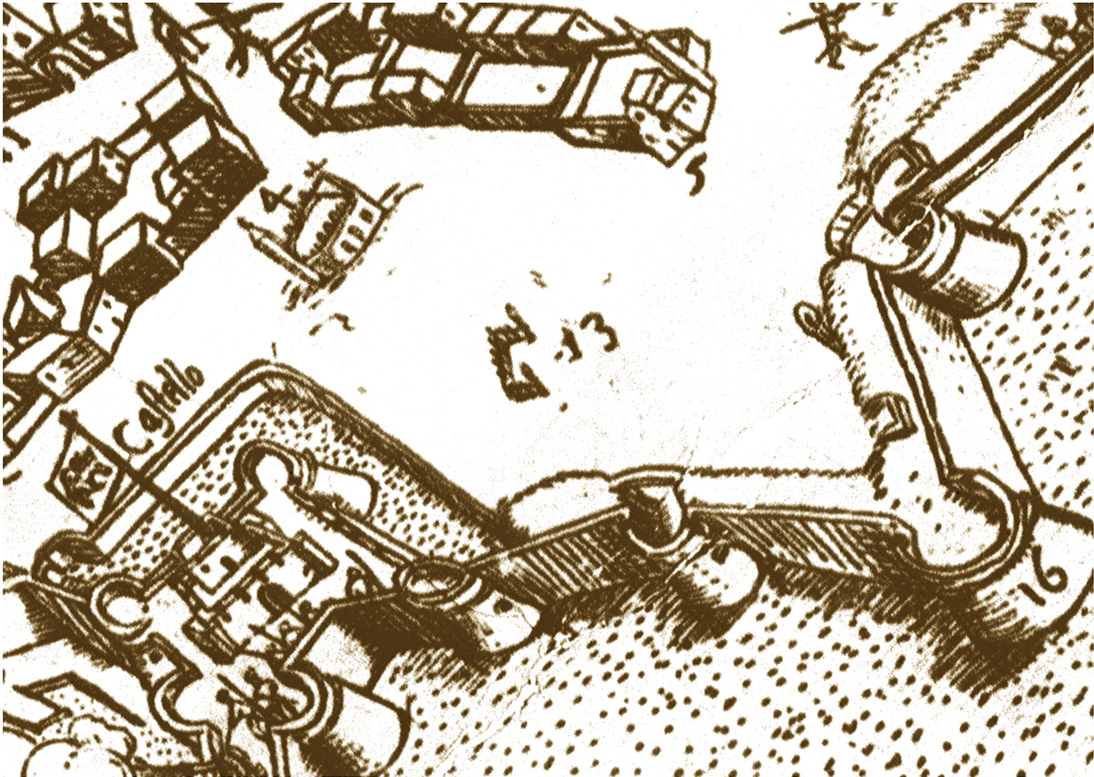
With in the city walls of Oldtown, popularly known as Oldtown of Famagusta, nearly 1300 years old and situated in the eastern cost of the island of Cyprus, the name “Ayia Photou Church” is given to two side by side antique monuments, 20 m. apart, which are now in ruins. These two ruins are situated at the north east sector of the town and are very close to the midpoint of Torrion del Diamante (Karpaz Tabya) and Torrion del Mozzo (Köpük Kulesi).
According to the new findings based on a dense research in archives and old texts, the name of the antique monument on the south should be “Ayia Photou Church” and the name of antique monument on the north should be “St. Dominic Church”.
In Famagusta, once a very rich town of Medieval, were two Bishoprics and seven churches of different [Christian] religious orders. One of them was the famous “St. Dominic Church” of Franciscan order.
The Dominicans were first arrived to the island around 1225 and their population was not very significant till the conguest of Acra. After the conquest of the city of Acra by Muslims on 1291, the King of Cyprus released an order and enabled settlements to the Christian immigrants of Acra to Kingdom of Cyprus. They were warmly well comed and the Dominic Church flourished as from this date and became one of the important and richest orders in the island.
In the gravure of Stephan Gibellino dated 1571 named “Citta di Famagosta”, the “St. Dominic Church” was clearly drawn with the belfry and backgarden encircled with highwalls and marked with No.5 and footnoted as “St. Dominic Church”. It was located on the north east part of the town and close to the midpoint of Torrion del Diamante and Torrion del Mozzo. On the east part of the church, hippodrome “loro di trar al palio” was drawn, which till1950’s this area served to the similar purpose.
Unfortunately the “St. Dominic Church” suddenly disappeared from the papers, documents, registries, records, archives and even memories after the conquest of the town by the Ottomans on 1571 although the Ottomans tried their best to preserve the antique monuments of Christian religion for almost 300 years and handed over the town to British on 1878 as it was on 1571.
The traces and location of the “St. Dominic Church” is now found by SAMTAY foundation of Famagusta, and needs to be declared officially and reborn again.
Abstract
Island of Cyprus could be well claimed to be the most visited place and best cartographically documented island in the world due to it’s location on the main maritime passage way from Europe to Holy Land and end of Silk Road to Europe. The island’s strategic importance through its situation at the cross-roads of Europe, Asia and Africa explains Cyprus’s turbulent history and the importance of its ports and cities.
A German archaeologist wrote in 1880, “He who would become and remain a great power in the East must hold Cyprus in his hand. That this is true, is proved by the history of the world during the last three-and-a-half millenia, from the time of Thutmes II of Egypt to the days of Queen Victoria.”
This foresight or advise is still valid even in the 21st Century.
Since the Phoenicians (10th to 8th Century B.C.), Assyrians, Egyptians, Persians, Ptolemies, Romans, Byzantine, Arabs, English (Richard I the Lion Heart), Frankish (French), Genoese (partly), Venetian (Italian), Ottoman (Turkish) and English ruled the island. During these periods names of the cities, towns, villages, ports, mountains, hills, rivers, streams, creeks, ponds, lakes, capes and similar geographic places kept changing.
Sometimes when reading a manuscript written down by a traveler dated back to medieval, it becomes very hard to understand what happened where because of the rapid change of the names due the different back grounds and languages of governing bodies and their forcibly change of names of the places on the island. In addition to this factor, the language-wise back ground of the traveling authors, which number to around one hundred different personalities and fifteen different languages also effected the differently pronunciation and recording of the geographic places on their notes.
Going through the existing manuscripts as from 23 B.C., maps of the island of Cyprus published since 16th Century and books written in medieval times, nearly 1000 different versions of the names of cities, towns and villages of Cyprus found due to the differently country-wise and language-wise originated travelers.
This research and compilation of these names will ease the problem of understanding the historical topics written in different languages during different ruling periods.
Maps
One of the first geographic manuscripts mentioning the name of Cyprus is Strabo’s “Geographica” [1] dated back to 23 B.C. and Claudius Ptolemeus’s “Geographice Hyphegesis” written in Greek dated 160 B.C. [2]. They both define the names of the cities and capes of Cyprus.
According to Herodotus, Aristogoras of Militus convinced Spartan King Cleomenes to assist the Ionians fighting against the Persians in ca 500 B.C. by pointing out to him the route to Susa on a map engraved on a copper plate [3]. This map is supposed to be the first map of island of Cyprus and the towns of Paphos, Soloae (Soloi), Lapheto (Lapithos), Cerinia (Keryneia), Citari (Kythrea), Salamina (Salamis), Cito (Kitium), Amathus (Amathus), Curio (Curion), Palephato (Palaepaphos), Tamiso (Kokkinotrimithia) ve Thremitus (Nicosia) are marked and the distances between them are indicated.
In Europe till the second half of 13.th century no outstanding progress was achieved in cartography. Especially in the western Europe, as of the other scientific studies, the cartography was also in the hands of clergy and they were drawn behind the walls of monasteries and bishoprics. These mappers, who were originally monks, abbots or monastic people, were collecting the necessary information mainly from the travelers or pilgrims and secondly from the mariners whenever they had the chance to meet them on the land.
The first map showing Cyprus alone is the map of Venetian mariner Bartolemmeo, dated 1480 AD. After the rumors of Ottoman preparations for an attack to Cyprus were widely spread, the maps showing the island of Cyprus with details and very close to real shape started to circulate.
Publications and Manuscripts of the Travellers
Cyprus as mentioned previously, were under the effect and pressure of the civilizations around the Mediterranean since early ages due to its very important location, being in the middle of the trade road between East and West, being on the roads to Holy Land and due to reasons originated from its unique geography.
When the “List of the names” attached to this paper is studied, it can be seen very clearly and amazingly that the name of the island of Cyprus has lots of different variations since the early ages.
These different and varied names are “Acamantis”, “Acamas”, “Acantida”, “Achamantide”, “Achametide”, “Aerosa”, “Amathus”, “Amatusa”, “Amathusia”, “Aphrodite Cypris”, “Aspelia”, “Aspellia”, “Astimono”, “Carastis”, “Carastoni”, “Cerasi”, “Cerastin”, “Cerastis”, “Ceraunia”, “Cethim”, “Cethin”, “Cethina”, “Chetim”, “Chetima”, “Chitim”, “Cipir”, “Cypre”, “Colinia”, “Collinia”, “Colonia”, “Copper”, “Cripton”, “Cytherea”, “Crytono”, “Cypiria”, “Cypris”, “Cypros”, “Crypta”, “Crypton”, “Cryptus”, “Kerastia”, “Macaria”, “Machara”, “Macharia”, “Marchara”, “Maxalia”, “Minois”, “Paphia”, “Qibris Adasy”, “Salamina”, “Salaminia”, “Spelia”, “Sphekeia”.
The number of sovereigns ruled and accordingly the different languages spoken in the island of Cyprus in the history is 13. This two digit number which is even greater than a dozen, of the different sovereigns ruled this island is one of the main cause of the change of the names of the towns, locations, rivers, points, capes, bays, mountains, hills, planes etc. in the island.
The second main reason is the travelers, who visited this island on their way to Holy Land for a pilgrimage since the flourishing of the Christianity.
As known very clearly that the pilgrims of the Europe willing to visit “Terra Sancta” the Holy Land, had no other choice but traveling by sea. The vessels departing from the port of Venice, propelled by the wind only, had to stop in the islands of Crete, Rhodes and Cyprus for a supply of victuals, water, salt for consumption and wood for cooking. The stay in these ports were of a minimum 4 days stretching up to 7 days or over.
The literate pilgrims who took this break as a chance to travel around and note down their souvenirs and perceptions, collected, edited and printed this information as a paper or in a book form on their arrival back to their home country. The number of such travelers are as much as one hundred and sixty seven [4] and they are from thirteen different countries. This variation caused the afore mentioned publications to be printed on thirteen different languages and accordingly each different language had its own unique pronunciation, spelling and writing of the islands geographic names.
The names of the geographic places they noted down were under the effect of heir native languages in pronunciation, spelling and writing wise. When these notes, books or papers were examined thoroughly, it is clearly seen that the geographic names they mentioned were altered under the pressure of their native tongues with out any intentions.
Effect of travelers on the geographic names
The cartographer Iacomo Franco and the other followers printed maps of the island of Cyprus since 1570 in at least 4-5 languages like Latin, Italian, French, Dutch, Flemish and German using totally different names for the same place based on the language they are using. Franco marked for the first time in the cartography total of 564 locations in his map of Cyprus while the total of the actual locations were 813 on the island.
A. & J. Stylianou [5] made a comparison study on Matheo Pagano 1538 map, Giovanni Francesco Camocio, 1566 map and Abraham Ortelius, 1570 map, to compare the exactness of locations in these maps of Cyprus with Kitchener’s 1885 Cyprus map [6] and published the results in their famous book titled “The History of the cartography of Cyprus”. This study also revealed some of the different names of the same locations used on these maps.
The traveling notes written down by 82 travelers compiled by C. D. Cobham under the title “Excerpta Cypria” and 85 travelers compiled by T. A. H. Mogabgab [6] under the title “Excerpts on Cyprus” contains total of 891 varied names of locations in the island of Cyprus including A. & J. Stylianou’s findings. As mentioned in the previous paragraph, 53 of these different names means or indicates the island of “Cyprus”.
Conclusion
The varying names of same locations based on the information given by the travelers or mentioned in their publications, were used very widely by the cartographers in their maps and by the time these numerous variations lead to serious complications on understanding clearly “what happened where”.
The people who are interested in the “History of Cyprus” when reading the manuscripts, books, traveling notes, itineraries, narratives, chronicles, peregrinations, maps and etc. end up with fogginess or mess up due to the unconformable location names mentioned. The subject studied on, becomes more and more complicated and most of the time end up with wrong results due to lack of a scientific reference as this research.
This paper will ease these problems and open up new horizons to the researchers of the “History of Cyprus” by giving birth to 891 previously unknown location names used in the island of Cyprus since antique age.
REFERENCES
[1] Cobham, C. D., Excerpta Cypria, Cambridge University Press: UK, pp 1, 1908
[2] Cobham, C. D., Excerpta Cypria, Cambridge University Press: UK, pp 4, 1908
[3] Stylianou A. & J. A., The History of the Cartography of Cyprus, Zavallis Press : Cyprus, pp 1, 162, 1980
[4] Mogabgab, Theophilus A. H., Excerpts on Cyprus, Zavalli Pres : Cyprus, pp. v, 1945
and
Cobham, C. D., Excerpta Cypria, Cambridge University Press: UK, pp iii, 1908
[5] Stylianou A. & J. A., The History of the Cartography of Cyprus, Zavallis Press : Cyprus, pp 17 to 24, 1980
[6] H. H. Kitchener, A Trigonometrical Survey of the Island of Cyprus, Edward Stanford : England, sheets 1 to 15, 1882
BIBLLIOGRAPHY
1) C. D. Cobham : Excerpta Cypria.
1.st Ed 1908, Cambridge, University Press, Kraus Reprint Co., Newyork, 1969.
2) Suphi Rıza : Mağusa’da Tarihi Yerler
2.nd Ed, Nicosia, Bolan Printing, 1989.
3) T.C. Genelkurmay Harp Tarihi Başkanlığı Resmi Yayınları No. 2 : Türk Silâhlı Kuvvetleri Tarihi, III’ncü Cilt, 3’ncü Kısım Eki, Kıbrıs Seferi (1570-1571) kitabı.
Ankara, Genel Kurmay Basımevi, 1971.
4) Hürriyet Matbaacılık : 100 Ünlü Türk İstanbul, 1977
5) Abdülkadir Dedeoğlu : Osmanlılar Albümü.
Osmanlı Yayınevi, İstanbul.
6) Antros Pavlides : History of Cyprus
Filokipros, 1992, Nicosia.
7) Rita Severis : Travelling Artists in Cyprus 1700-1960
Philip Wilson Publishers, London, 2000.
8) Halil Giray : KKTC Yerleşim Birimleri
Gazimağusa ve İskele İlçeleri, Yürürlükteki ve Eski İsimler Listesi
9) KKTC İskân Bakanlığı : KKTC Coğrafi İsimler Kataloğu : (Cilt – II),
Lefkoşa
10) Theophilus A. H. Mogabgab : Excerpts on Cyprus
The Pusey Pres, Nicosia, 1941
11) D. G. Hogarth : Notes of an archaeological journey in Cyprus in 1888 (Devia Cypria)
Henry Frowde Pres, london, 1889
12) Sir David Hunt : Footprints in Cyprus
Trigraph Ltd., London, 1982
13) Kypros Tofallis : A History of Cyprus
The Greek Institute, London 2002
14) Oğuz Yorgancıoğlu : Kıbrıs’ta Türkçe Yer Adları ve Veriliş Yöntemleri Üzerine Bir Araştırma
Kıbrıs Araştırmaları Dergisi, Cilt : 2, Sayı : 3, Yıl : 96, s. 267
15) Halil Giray : Geçmişten Günümüze Kıbrıs Harita ve Planları,
Üçüncü UIuslararası Kıbrıs Araştırmaları Kongresi, 13-17 Nov 2000, Cilt 1, Tarih, Yatına Hazırlayan : İsmail Bozkurt, s. 62
AENCYCLOPAEDIA
1) İbrahim Alaettin Gövsa : Türk Meşhurları Ansiklopedisi.
Yedigün. İstanbul, 1946.
2) Ana Yayıncılık : Ana Britannica Genel Kültür Ansiklopedisi
İstanbul, 1994.
3) Encyclopaedia Britannica Inc : Encyclopaedia Britannica
Universal Copyright. USA, 1966.
4) Filokypros E. E. Ltd.: Megali Kupriaki Egkuklopedia
Nicosia, 1985.
5) Webster Publishing :
Webster’s World Encyclopeadia 2002 CD rom.
6) Meydan Larousse : Büyük Lugat ve Ansiklopedi,
Sabah Yayınları,İstanbul, 1992.
7) Oxford Ansiklopedik Sözlük : Yılmaz Yayınları A.Ş.
Sabah Yayıncılık, İstanbul, 1990.
MAPS AND ATLASSES
1) A. Hadjipaschalis, M Iacovou : Maps and Atlases
Bank of Cyprus, Nicosia 1989.
2) Hürriyet, Naumann & Göbel : Grosser Weltatlas
Hürriyet Gazetecilik ve Matbaacılık A.Ş. İstanbul, 1993.
REFERENCING MAPS :
1) Pierre Mortier : Map of Natolia, Asia Minor,
Anetore PHI. De la RUE. Amsterdam, 1700.
2) Abraham Ortelius : Peregrinations divi Pauli Tyrus Corographicus
Antwerp, 1595.
3) Gabriel Bodenehr : Das Mittelaendische Meer,
Augsburg, 1730.
4) Guiljelmus Et Iohannes Blaeu : Turcicum Imperium,
Almanya, 1641.
5) Francois De L’isle : Tabula itineris Decies Mille.
P. du Val Geographe du Roy. Fransa.
6) Isaak Tirion : Nuova Carta del Europa Turchesca.,
Amsterdam.
7) R. Spofforth Sculp: A New Map of the Eastern Parts of Asia Minor.
1714, İngiltere.
8) George Braun – Frans Hogenberg : Calaris-Malta-Rhodus-Famagusta. Civitates Orbis Terrarum. Cologne, 1599.
9) Abraham Orteliu : Cyprus Insula Laeta Choris
Theatrum Orbis Terrarum, Antwerp, 1608.
10) Cornelis Claesz – Petrus Bertius : Descripto Cypri,
Caert-Throsoor, Amsterdam, 1603.
11) Gerard Mercator (Haritacı) – Jodocus Hondius (Yayıncı) : Cyprus Insula,
Amsterdam, 1607.
12) KKTC İskân Bakanlığı Harita Şubesi, TC. Harita Genel Komutanlığı, 1995
Kıbrıs Fiziki Haritası, Baskı : 1 THGK
13) J. Wyld Geographer : Map of Cyprus,
London, 1878.
14) H. H. Kitchener : Island of Cyprus, London, 1882.
15) A Visitor’s Map of Cyprus : Department of Lands and Surveys,
Cyprus, First Edition 1986, 4/94.
16) Benedetto Bardone : Venedik, 1534.
17) Pierre Mortier – Philippe de La Rue : Anatolia-AsiaMinor, Amsterdam, 1700.
18) Kemal Rüstem & Brother : Cyprus (North & South),
Prepared by Oxford Cartographers, 1989
19) Kıbrıs İdari Taksimat ve Karayolları Haritası
MSB Harita Genel Müdürlüğü, 1972.
20) Lazkiyye : Carte de L’empire Ottoman,
Chez. CH. PICQUET, 1816 – 1836, Orleans, Fransa.
21) Les Estats de L’Empire des Turqs en Asie. : Parle Sanson D’Aabberville.
Geographe Ordinaire du Roy A, Paris, 1684
22) Questa e la uera descriptione et Geographia de tutta linsula de Cypre : Stampata in Venetia per Matheo pagano 1538 [1940]
23) J.P. Foscolo : Island of Cyprus . 1550,
24) F. Bertelli : Isola di Cipro . Roma, 1562
25) J.F. Camotii : Cyprus, insula nobilissima : expensis in oes incisa. Venice, 1566
26) N. Bonifacio Sibenicensis: Cyprus Insula. Venice, 1570
27) N. Nelli : Cipro. Venice, 1570
28) P. Forlani : Carta ou’e distintamente e fedelmete descritta 1’Isola di Cipro; il porto d’Anemur, fatto, e fortificato dal S. Turco nella Caramania, dirimpetto a detta Isola; e una gra parte dell Soria. Venetia, 1570
29) No name : Cyprus, quae oilm Macaria id est Beata, Insula, est in sinu Carpamii maris sita : Venice, 1570
30) Apud A Egid : Cyprvs Insvla Antverpiae. Coppenium Diesth, XX. May, 1570
31) A. Lafrery: Disegno de 1’Isola di Cypro con li Confini della Caramania, Soria, Giudca et Egitto. Roma., 1570
32) G.F. Camotti : Cipro, insula nobilis. Venice, 1571
33) Joannes A : Deutecum Cypri Insvlae Nova Descript.
34) Cyprvs, Insula laeta choris, blandorum et mater amorum Antuerpiae Ambivaritorum, 1584
35) G. Mercator : Cyprus Ins. Amsterdam, 1636
36) P. Mariette : Cyprus Insula Lutetiae Parisiorum. 1650
37) J. Wyld : Map of Cyprus. London, 1878
38) Map of Cyprus. ([Scale, circa, 8 miles to an inch]) London, 1878
39) H. Kiepert : New Original Map of the Island of Cyprus. Scale,
1 : 400,000 Berlin, 1878
40) H.H. Kitchener : A Trigonometrical Survey of the Island of Cyprus.
London : E. Stanford, 1885